
 2021 JFK 50 Miler
Framing Chicago: Sub-Chicago
Sub-Chicago

We live in the part of downtown Chicago where one can find a system of multi-level streets. I found this a little odd at the beginning, but then got used to it and now I see the advantages of the system. Our building has an entrance on both levels respectively, the official entrance with a lobby and a concierge is at the upper daylight level. The lower level has the service entrance and the loading dock for trucks of moving companies and deliveries, street names and addresses are the same. Residents can use both levels.
City planners in Chicago have thought about raising street levels many times in the course of the city´s history. The low level of the Chicago Portage site and swampy conditions challenged the cities inhabitants right from the beginning. Rapid population growth after the founding of the city led to intolerable sanitary conditions, streets were constantly muddy and transportation became difficult as increasing numbers of carriages filled the streets, competing with the many pedestrians. A plan was laid out to install the country´s first comprehensive sewerage system, and in this context the streets were raised for the first time between 1855 and 1858. Since then raisings have been altered, updated and expanded according to the needs and necesseties of the infrastructure.

Many of the well known landmarks also have a sub-level life

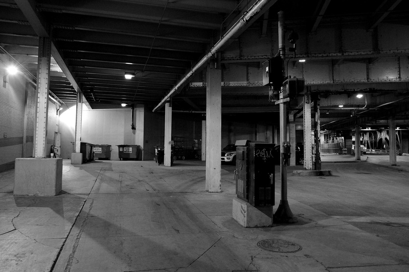
Most sub-level streets north of the Chicago River aren´t as busy
as the ones on the south side, e.g., Lower Wacker Drive

In the beginning people warned us to use the lower levels because of dangerous
underworld activities. So far I couldn´t detect a thriving thug industry,
Chicago´s crime rate seems to unfold in other parts of town

Every once in a while you´ll find an exit staircase to real street life above
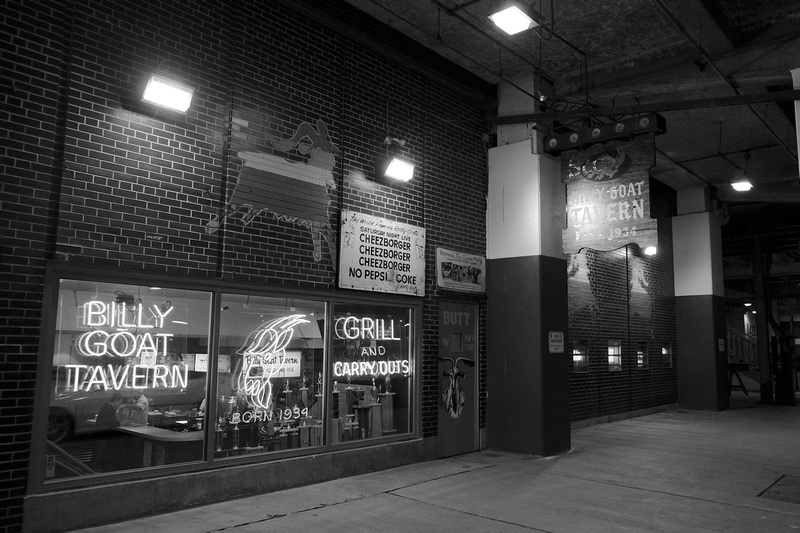
The famous Billy Goat Tavern is also located on the sub level
and never sees daylight - definitely part of its myth-making

The sub-level was also made to provide for better infrastructure in a
transportation context, hence hardly any pedestrians can be seen

Michigan Avenue leading to DuSable Bridge heading south towards the loop.


Comments
|
January
February
March
(5)
April (5)
(15)
May (15)
(6)
June (6)
(1)
July (1)
(4)
August (4)
(10)
September (10)
(12)
October (12)
(14)
November (14)
(12)
December (12)
|
(22)
January (22)
(14)
February (14)
(21)
March (21)
(11)
April (11)
(13)
May (13)
(14)
June (14)
(1)
July (1)
(2)
August (2)
(7)
September (7)
(15)
October (15)
(17)
November (17)
(18)
December (18)
|
(5)
January (5)
(14)
February (14)
(5)
March (5)
April
(5)
May (5)
(21)
June (21)
(13)
July (13)
(6)
August (6)
(11)
September (11)
(9)
October (9)
(10)
November (10)
December
|
January
February
March
April
May
(10)
June (10)
(15)
July (15)
(16)
August (16)
(4)
September (4)
(2)
October (2)
(8)
November (8)
(5)
December (5)
|
(6)
January (6)
February
(2)
March (2)
(7)
April (7)
(4)
May (4)
(5)
June (5)
(7)
July (7)
(2)
August (2)
September
October
(9)
November (9)
December
|
(1)
January (1)
(1)
February (1)
(7)
March (7)
(8)
April (8)
(3)
May (3)
June
July
August
September
(1)
October (1)
(14)
November (14)
(8)
December (8)
|
(8)
January (8)
(5)
February (5)
(9)
March (9)
(4)
April (4)
May
June
July
August
September
October
November
December
|
(4)
January (4)
(3)
February (3)
March
(1)
April (1)
(1)
May (1)
(2)
June (2)
July
(1)
August (1)
(2)
September (2)
October
November
(2)
December (2)
|
(5)
January (5)
February
(2)
March (2)
April
May
June
July
August
September
October
November
December
|
January
February
March
April
May
June
July
August
September
October
November
December
|
(3)
January (3)
(2)
February (2)
(1)
March (1)
(1)
April (1)
May
June
July
(3)
August (3)
September
October
November
December
|
January
February
March
April
May
June
July
August
September
October
November
December
|
January
February
March
April
May
June
July
August
September
October
November
December
|